Sunday, July 18, 2010

Down the Mississippi, to the Ohio, to the Cumberland (pictured). Almost "home."

Exiting the LAST LOCK!!

My first and last marina - at Kentucky Lake, TN. "Crossing my wake" 5300 miles later.


THE END • Saturday, July 17, 4:30 MDT
8 weeks and 1 day from start to finish. What an amazing adventure. Thanks for sharing in my journey, Lyn

Friday, July 16, 2010

The timing didn't seem right - I had a bit of laryngitis, scratchy throat and thunderstorm chance today was 50%. After getting my blog to Joanne for posting Thursday night I realized it was 10:00 and the taxi was scheduled for 4:30 AM. It was time for a day off and this morning I feel good and the chance of storms for today onward has been downgraded. The heat warnings remain however, and probably another reason to get myself back to normal today before undertaking the final push tomorrow. This leg of the trip, 250 miles, could theoretically be done in one day but the 3 locks I must traverse are the wild card potentially causing delays exceeding 2 hours.

Yesterday, after leaving the fine folks at Grafton Harbor, I should have been to Hoppie's Marina easily before noon with only the two locks in the St. Louis area. As it was it took all day to go 50 miles and the heat index was over 100. Both locks were making repairs so I had to wait for commercial traffic and the barges move at glacial speed. It was one of the worst days of the trip and the longest delays I've experienced in about 130 locks.

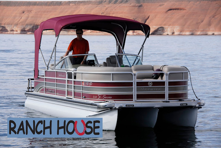
Despite some first aid on the middle pontoon, the Premier Pontoon has performed extremely well and garnered many comments from people who realized it wasn't the average pontoon. Of course people could not believe I was doing the Loop in it. Despite being beaten by waves there is nothing loose on the boat - the gates, 5 rail "fence," and wind screens remain very solid. The all-weather carpet looks great but will need a cleaning. The nano-technology seats look like the day the boat was delivered. Salt water is hard on materials and because I could not rinse it everyday the swim ladder and a few metal fittings may need to be replaced. I have put a few dings in the bow and stern plates which will need attention. It is the only boat of this type I would consider for big lakes and a comfortable ride. It is very well screwed together.

The technology I've relied on are my Asus Netbook, used every night for planning, weather and blog. Verizon Incredible phone for taking pictures, weather radar during the day, and g-mail, looking up motels, etc. on Google search. Used 12 v boat charger for it during the day. SPOT locator which I've already discussed - essential item especially for solo trips of any kind (does not depend on cell phone connection, uses satellite). Lowrance 7” GPS mounted on the boat for electronic charts, speed, distance, sonar for depth and bottom conditions. Use this in conjunction with paper charts for navigation. I don't recommend Lowrance due to a screen failure, failure of cursor keys to function periodically, poor corporate customer support and slow refresh rates which are maddening when you are attempting to use the other functions. Hallberg Marine, my dealer, saved the day by overnight shipping a new unit to me when the screen failed. I carried a compact camera but did not use it much due to adequate phone pictures and lack of time to use both. I also carried a handheld Garmin GPS in case the Lowrance failed and this was used the day the Lowrance screen failed. A marine portable radio is essential for safety, talking to other boats, locks and getting marine weather. 12 v and AC chargers are essential for any chargeable devices as well as extra batteries. The Yamaha engine included dash gauges that gave me fuel consumption at different RPMs, gallons used, MPH, trip miles, and engine hours to track maintenance. That summarizes most of the technology I used.

Thursday, July 15, 2010

Sally delivering goodie bag from Grafton Harbor folks in celebration of my trip.

A great harbor with friendly and knowledgeable folks.


Tow past Grafton into St. Louis Harbor


The Arch in St. Louis... drove by it in September and boated by it today.


The mighty Mississippi from Hoppie's Marina in Kimmswick, MO.

Hoppie's Marina from the River.

Fern Hoppie at the helm.

Tomorrow is it! Weather permitting... the beginning of the final two-day leg of this journey and the longest and most remote without fuel or services. At Hoppie's Marina this afternoon I filled up the boat and four 5-gallon gas cans. I have to have enough fuel to go 250 miles to Kentucky Lake. My best fuel economy balanced with speed is around 20-23 mph and that is fast enough on the Mississippi. It is at low flood stage so the occasional sandy banks are gone - just the tree lined river. This is a disadvantage if you just want to take a break or even camp. There are a lot of logs, trees and other matter floating down the river at 3-5 mph so you have to keep a good lookout.

The taxi will pick me up at 4:30 in the morning and I hope to make the mouth of the Ohio River and find a safe harbor off the river for the night - this is usually a creek or dead water off the main channel. I'm sure my mosquito netting will come in handy. The heat advisories continue and today was brutal, but I did drink more fluids on a regular basis. Then, on to Kentucky Lake via either the Tennessee or Cumberland River. Both have a lock that locks you up to the lake - Cumberland is a little less busy with commercial traffic but 30 miles farther.

If I were to have a mechanical failure of some sort I would press the "Help" button on my SPOT and Joanne would contact this region's Coast Guard and send them the coordinates of my location. If it were a life threatening emergency I would press the "911" button and it summons regional and local rescue immediately via satellite.

Fern Hoppie gave me the scoop on my route and said I will have cell service at times but no other services along the way. There will be an occasional "put in" ramp used by locals but no services. I will need one of these when it’s time to put my extra fuel in the boat. Fred Martin and I found out how hard it is to fuel the boat on the water while crossing the Gulf, and that was with two people. The newly mandated EPA cans make life more difficult, not safer. Thank you big government.

My next blog will likely be after the completion of the trip. I appreciate everyone's interest and support and know that many of you followed without posting comments. I hope this has been as fun for you as for me - but don't leave yet, we need to determine what I learned from this experience, what pieces of equipment were useful and what lessons you can apply to your next adventure. Alarm goes off in 6 hours so must close for now.

Wednesday, July 14, 2010

Mississippi River where the Illinois River joins - and a tow.

Smaller tow boat

CHICAGO by Carl Sandburg

Hog Butcher for the World,
Tool Maker, Stacker of Wheat,
Player with Railroads and the Nation's Freight Handler;
Stormy, husky, brawling,
City of the Big Shoulders . . .

This is the beginning of Sandburg's poem that I have been reminded of the past few days as I've traveled from Chicago to the terminus of the Illinois River where it joins the Mississippi. The entire poem is one of my favorites. From the harbor south of Chicago to here in Grafton, Ill, a picture of industry in America emerges including agriculture with grain being loaded onto barges for shipping to New Orleans and the small towns where people go about everyday life living perhaps an entire lifetime within 25 miles. Despite the barges, power companies, grain elevators and small towns engaged in whatever they do, much of the river is long stretches of solitude and trees along the river bank.

As I said in the previous posting, tomorrow I travel to the famous Hoppie’s Marina, 50 miles below St. Louis and prepare for the final 240 miles. Increased chance of thunderstorms from tomorrow night through Friday. Why are there no boat services in that distance other than some public ramps here and there for the locals? Many of the towns along the Mississippi have continuously moved their river facilities and towns farther inland after each major flood prompting them to forgo river services entirely. Supposedly Paducah, along the stretch of the Ohio I must travel, has applied to build a public marina near town. This would be a plus for boaters traveling from the Mississippi up the Ohio 30 miles, then the Tennessee River a short way up to Kentucky Lake. I may have to "anchor out" Friday night along the river in a storm hole to complete the trip on Saturday. The SPOT may be my only communication. We'll see.

Tuesday, July 13, 2010

Unloading a barge on the Illinois River

Leaving some of the Illinois River behind.

Approaching a tow boat.

Ottawa last night, Havana tonight - did I change course? Actually these are towns on the Illinois River and tomorrow I plan to arrive in Grafton, Ill where the Illinois joins the mighty Mississippi.

Thursday to Hoppie's Marina - 50 miles south of St. Louis where the longest stretch of my trip begins and gasoline is not available, nor any other services. That is the 240 miles from Hoppie’s, located in Kimmswick, MO to Kentucky Lake, TN where I began this trip and will “cross my own wake.”

Hoppie’s is famous as Fern Hopkins and her husband hold court every afternoon for those venturing south on the Mississippi. Their "marina" is actually several barge platforms tied together sitting along the banks of the River. Here is a picture: http://www.marinas.com/view/marina/5146_Hoppies_Marina_Imperial_MO

But first things first. Most of my trip has taken place when heat advisories were taking place. Tomorrow there are heat index warnings again for this and the Mississippi area extending into the end of the week. I need to drink more water during the day on the boat, but usually what happens is I get to my destination and realize I'm a bit dehydrated and then spend the evening tanking up, not a balanced approached. Tomorrow I plan to stay at the Reubel Hotel in Grafton - if I begin by 7:30 AM I could get there early afternoon and "chill" out. It is 120 miles and at 25 mph about a 5-6 hr. trip.

The Illinois River is somewhat narrow in places and if you consider that navigation aids in places narrow it further then the space between me and a tow pushing barges ahead of it is not comfortable. Actually I slow down and determine which direction the end of the tow will hang out and cruise by the other side. When turning into a curve, the tow (actually it's pushing the barges) will swing to the outside of the curve. You don't want to be there as you will end up in his wake and maybe outside the channel markers.

While I can visualize the end of this journey it is important to take each of the final days one at a time. Don't make any mistakes, keep track of my location on chart and GPS and enjoy the scenery. I'm in corn and bean country and while I can't see that from the river I did see it last night from the 3rd floor of my motel - a corn field and water tower, just like the one in Goodland near where my folks lived their final years. Many memories all of a sudden came to mind when I opened the curtains of the motel and saw that scene - with a thunderstorm in the background thrown in for good measure. Wow, you just never know where the great river of life will lead. And so it flows . . . . .

Michigan City breakwater and harbor - July 11.

Lake Michigan allowed my passing over three days but not without an argument. Fog on first day and rough water the third.

Today, July 12, I left Michigan City, IL and had 30 miles of open water to the Calument Harbor 10 miles south of Chicago. Then via the Calument River to the Illinois River. It is 300-plus miles from Lake Michigan to the Mississippi River.

I arrived at Ottawa, IL after a long, 125-mile day. Have not encountered any flying carp yet but expect to tomorrow - will keep my head behind the windscreen! May make Havana, IL Tuesday. Passed through 4 locks today - will not miss the locks (about 130 on the Great Loop) but only 5 more before arriving at Kentucky Lake where the SUV and trailer are stored.

American industry is at work on the Calument River, the first 50 miles off Lake Michigan, where I passed today. Power plants, chemical, rail, auto, marine repair were all in evidence. The barges (tows) were numerous and up close as the Calument is not that wide. I had to stand by when barges approaching were passing barges tied up on the other shore - not much room to maneuver. Too late for more - a great day.

Saturday, July 10, 2010

Leaving Frankfort, MI at 0700 this morning.

Boat traffic in Grand Haven, MI this afternoon.

George Gershwin's, "Summertime" first verse, began to play in my mind this evening. "Summertime and the livin' is easy, fish are jumpin' and the cotton is high.” This does not apply to many Americans right now but I love the tune of the song. Some Canadian marinas are busy and the east side of Lake Michigan is way too busy at least on this weekend of my journey, and yet the "recovery" for many Americans is not happening. I have so much to be thankful for, not only for family but what this country has provided me. I give thanks along this journey knowing that many people in our world are less fortunate.

Yesterday, from DeTour, MI I traveled through the Mackinac Straights, around Mackinac Island and down Lake Michigan to Frankfort on the eastern shore. Intermittent fog and use of waypoints on the GPS was the rule of the day. Once again my horizons were land on one quadrant of the compass and a horizon of water on the other three. This is a huge lake and the small boater is constantly aware of potential weather changes that can happen quickly. One reason for this trip was to build on past experiences and my interest in weather, navigation and decision making. A constant assessment of current circumstances and the potential for those to change, taking nothing for granted, seems to be a good rule of thumb for most endeavors.

Today the water began with swells into my direction of travel limiting speed to 15 mph. Later, the water calmed and the shoreline with many sandy beaches was my view several miles to port. Accommodations, without reservations are almost nonexistent and the price for average amenities is near $200 - I dislike traveling on weekends. I almost camped on the beach yesterday after calling 7 hotels that were booked, but that would have prevented me from making accommodations for today as there was no phone or internet service unless you were near a town. Sunday nights and weeknights are manageable. The coming week should find me navigating the great Illinois and Mississippi Rivers... the "big waters" left behind, the Great Rivers offering their own challenges, and my own nostalgic version of Summertime playing a river tune.

Including a video this time - it's the stern view showing fog yesterday morning.

Thursday, July 8, 2010

Looking north from De Tour Village, Michigan

De Tour Marina

No blog from the Mariner today because he doesn't have wifi where he's staying. He "marinated" (sorry... couldn't resist) 105 miles today from Little Current, Ontario, through the North Channel, turned left (port) before reaching Thessalon and headed back into the United States. Tonight, he's in a charming little town called De Tour Village, Michigan. Tomorrow he'll head across Lake Huron toward Mackinac Island, go under the Mackinac Bridge and enter Lake Michigan. Lyn plans to navigate down the east coast of the lake. Wish I was there. JM

Wednesday, July 7, 2010

Fog this morning made it necessary to tie up to this buoy for half an hour.

The beautiful Collins Inlet

Killarney lighthouse

Welcome to Killarney

Little Current, Ontario - picture post card perfection.

These little guys were for sale!! Joanne wants both of them...

Town docks in Little Current

It was clear and there was a breeze when I left Britt for Killarney and Little Current, Ontario at 6:30 this morning. After 15 miles on Georgian Bay (part of Lake Huron) I ran into a fog bank and had to tie off to a navigation aid buoy as I couldn't see the next marker - pea soup. I sat there in complete silence for 30 minutes listening to a loon until the fog lifted and I could see the land and next marker. It was too narrow an area to depend on the GPS. It would have worked in open water which I crossed later with quarter-mile visibility but then you have to worry about other traffic. Saw only a few local fishing boats on the water in 85 miles of travel. Both Killarney and Little Current have a lot of 35-45 foot cruisers and sail boats tied up at the docks. Otherwise everyone here is complaining about a heat wave that is also plaguing the eastern U.S. My room does not have AC so you sweat after you take a shower. I’ll walk to the town dock before it gets dark. My phone does not work here and this is about the first place on the trip that Verizon hasn't worked. Only the bar here has WiFi - how convenient!!

The Collins Inlet between Beaverstone Bay and Killarney is probably the most pristine and beautiful place I've seen on this trip and maybe anywhere. The banks are granite rising out of the water and leaning inland covered with pine trees. Not mountains, but higher hills than most of the terrain I've traveled. I was told you can find Georgian Bay or North Channel videos on YouTube so you might give that a try. My pictures and narrative really can't describe the scenery adequately. Water lilies with white blooms lay along the shore, muskrats were playing and an occasional eagle flew reconnaissance. I cannot recall having that lump in the throat for “just terrain” - it is perhaps a magical kingdom.

The bar has turned up the TVs for soccer or whatever and I must leave - it is too incongruous with the day I have just experienced. So much to describe.

Tuesday, July 6, 2010

Watched a plane taxi from where I ate lunch.

Thanks to Vanessa who has made sure Joanne gets flowers on those special occasions. Vanessa was a highly trained paramedic and then decided to start her own floral business called Vintage Magnolia in Edwards, CO. She and partners do outstanding work and their reputation and success reflects their talent so if you need gifts or floral work stop by her business next to the Bookworm in Edwards or call 970-926-5000.

Today was 100 miles from Honey Harbor at the beginning of Georgian Bay, Ontario to Britt, on the Byng Inlet. A very small town and several marinas, restaurants and post office. If you enlarge my last SPOT location on "terrain" you will see the Trans-Canada Highway crossing over the inlet to the right. This is otherwise remote country except for summer cottages on the numerous small islands. There was a large timber industry here beginning in the 1800s until the early 1900s then the town became a coal receiving point for the locomotives on the emerging Trans Canadian Railway system.

The navigation in this region is nerve wracking as there are rocks just under the surface, even in the big water away from shore. If you do not closely follow the red and green navigation aides and keep your "other two eyes" on the GPS and chart you can run into trouble quickly. When you are on route and look down and see the bottom passing 5 to 10 feet under your boat, it gets your attention. So, not much chance for pictures today. I have traveled over the Canadian Shield most of my trip since entering Trenton, Ontario from the U.S. Here is a description and reasons for the shallow water in many locations, not to mention its unforgiving nature compared to mostly mud bottoms on the east coast waterways. http://en.wikipedia.org/wiki/Canadian_Shield

Since I don’t have to wait for locks to open at 8:30 on the Trent-Severn system (yes, they have unions!) I am now free to leave in the morning anytime I like which is usually between 6 and 7 AM. If there is any secret to such a trip as this, it is getting an early start in order to get some mileage before the winds get too strong and thunderstorms begin to form. It is a safety factor for obvious reasons and a chance to relax in the mid afternoon/evening, update the blog, see a little of the town I'm in, read charts and plan stops and lodging, wash out clothes, watch the weather channel and eat, after what is often a one meal day. From the time I get up at 5:00 I really don't have a lot of free time and still get to bed by 10. Many of the places I view from the water, and what's unseen beyond the shore, warrant a road trip and several lifetimes.

Monday, July 5, 2010

This is my cabin for tonight. What a great day!! Following is THE DAY IN PICTURES...

THE DAY IN PICTURES: Approaching Big Chute Marine Railway Lock. The boats on the lift have just come up from the other side. Notice they are not in water.

Loaded onto boat lift - locking down.

Looking back at the water level I am leaving.

Looking ahead to where I'm going. Is this Elitch Gardens??

Looking back at the ROAD we just crossed.

Going down...

The tracks...

Back in the water.

Looking back at Big Chute Marine Railway Lock in the distance.

Approaching the last lock on the Trent Severn Waterway... there are 44 locks on the canal.
The doors on this one are hand cranked.

Welcome to Georgian Bay... YA-HOOOOOOOOO!!


Sunday, July 4, 2010

Here they are... geese in Orillia Park.

Orillia Park

Bridge Port Marina

Spent two extra days in Orillia, Ontario due to needing a re-weld of a crack in middle pontoon; I have been through some rough water. Ready to go first thing tomorrow to pass through final 4 locks including the famous Big Chute Marine Railway Lock mentioned in previous blog. Take the time to look up this and the Peterborough Lift Lock - YouTube has videos. Then on to Honey Harbor at the beginning of the Georgian Bay.

Orillia is a great place to be for a layover. A large park on the water near the hotel with a terrific bike and walking trail. Many Canadians out on the water in boats and sunning in the park for the close of their Canada Day holiday weekend. Roller blading is very popular around the park trails. Many dogs were also being treated to a day at the lake! The Canada Geese get an honorable mention as well.

Once again I experienced Canadian hospitality and professionalism at the Bridge Port Marina. A well-trained team led by general manager Kyle and his crew of Deirdre and Glenn in addition to dock and parts staff. Kyle was able to locate a welder who could come in on a Sunday. $$$$ but looks like a good job.

Also heard from Steve Schultz today via voice mail as he is in Vail for a short time. Steve is one of the legends at the Eagle County Ambulance District being not only an excellent paramedic, artist and designer of the district logo, but national president of the Edsel Club, not to mention being one of the nicest people you could meet. Steve moved to Arizona some time ago. He borrowed a cell phone to call me during the Vail 4th of July parade. Steve is often not traceable. Hello Steve!

Friday, July 2, 2010

Unusual arch on Trent Severn from a canal to a lake.


Peterborough Lift Lock

A couple more photos from July 1st trip.
Big lock

Lock dog greets everyone. What a great face!

Perfect house

Hydraulic lift lock - when I am at the top

Hydraulic lift lock - when I am at the bottom

Happy Canada Day! Yesterday was a national holiday, similar to our 4th of July. I've finally made my way towards the end of the Trent Severn Canal through central Ontario as of Thursday July 1. Over 230 miles from Trenton, Ontario to Georgian Bay with 36 conventional locks, two flight locks, two hydraulic lift locks and a marine railway. After 4 days of below average temps (60s during the day and windchills in the 40s) and high winds directly into my face most days, I am taking a day off in Orillia Friday. Still one more day on the Severn River to reach Georgian Bay and I will experience the only marine railway lock in the world, the Big Chute with a 57 ft. drop.

It is worth your time to look up YouTube videos of both the Petersborough Lift Lock and the Big Chute Marine Railway lock. They are spectacular and such a testament to ingenuity. The locks don't open until 8:30 on the TS each morning so it is hard to get an early start and waits for the lock to fill or empty from the other direction are common. Wednesday I got to the first lock of the day at 8:30 and by 2:00 in the afternoon had traveled a grand total of 36 miles. You cannot predict where you will end up at the end of the day and this makes planning for accommodations difficult. I may be sleeping on the boat after today for awhile as this weekend is like our 4th of July and most things are booked. Will be glad to leave the locks behind, as interesting as this waterway has been.

This is a beautiful country, and so far the Canadians, have been consistently gracious hosts. I have yet to experience one case of poor service or attitude. On at least two occasions, including yesterday afternoon at the Bridge Port Marina, staff have volunteered to drive me to my hotel. At one lock yesterday the lockmaster called to locate lodging for me. One of the hallmarks of great customer service is consistency. I did not experience that in the U.S. - one day the interface with service people was good to great and the next it could be dismal. Employees are poorly trained at many small businesses - it is just dependent on how sharp the management is.

Another challenging experience on big water on inland lakes yesterday crossing Lake Simco to Orillia. I knew it would be rough due to the windy weather and had read the cautionary notes about the lake. I could/should have turned back to the canal but after an hour of 12 mph and 20 more miles to go, a 40 ft. cruiser passed along my route so I managed to get into his wake water which calmed things considerably and I was able to make it to Orillia by 4:00 P.M. making 20 mph.

Today is a laundry and route-planning day. While I will not have any more locks after tomorrow the navigation becomes very important due to many rocks just below the surface in much of the route from here to Lake Michigan. Red buoys will be on my right and green to my left as I head west on Georgian Bay and then thru the North Channel. If you lose sight of your next marker, STOP, determine where you are and proceed. The water can vary from 20-feet deep to 1-foot deep in a matter of several yards. I should explain that the navigation aids in the water or along the shore are not like following the white lines on a highway - they may not even be within eyesight so you have use your chart and the GPS in addition to the navigation aids in the water to stay within safe, navigable waters.

On the days when I do not post blogs the reason for that is due to no wi fi access, and that may be the case for awhile. My SPOT locator will work anywhere so you can still track my daily whereabouts.